Cane Bayou
Written by Byron Almquist
Cane Bayou- a tributary of Lake Pontchartrain is a living classroom of habitats, history of man’s activities and a recreational waterway.
Cane Bayou is a waterway that flows into Lake Pontchartrain from the north shore. Located between Mandeville and Lacombe, Louisiana, Cane Bayou is the boundary between two public lands – Fontainebleau State Park to the west and Big Branch Marsh National Wildlife Refuge to the east. By using Goggle Earth, a paddler can locate the bayou and view pictures taken by previous visitors.
There are approximately ten bayous that flow into Lake Pontchartrain. All have been altered extensively in the last 300 hundred years. There is one exception – Cane Bayou which is still largely in a natural state. By being bordered by public lands on both sides, Cane Bayou should retain its natural appearance for the indefinite future.
Cane Bayou in its one mile distance to Lake Pontchartrain flows past or through several habitats. At the launch site, the terrain is known as pine flatwoods. What is striking is that this launch site is at what was once the very edge of the North America continent. From that site out to the Gulf of Mexico, the land has been filled in by the Mississippi River over a period of several thousand years. The Mississippi River water and the open waters of the Gulf of Mexico once were next to the launch site.
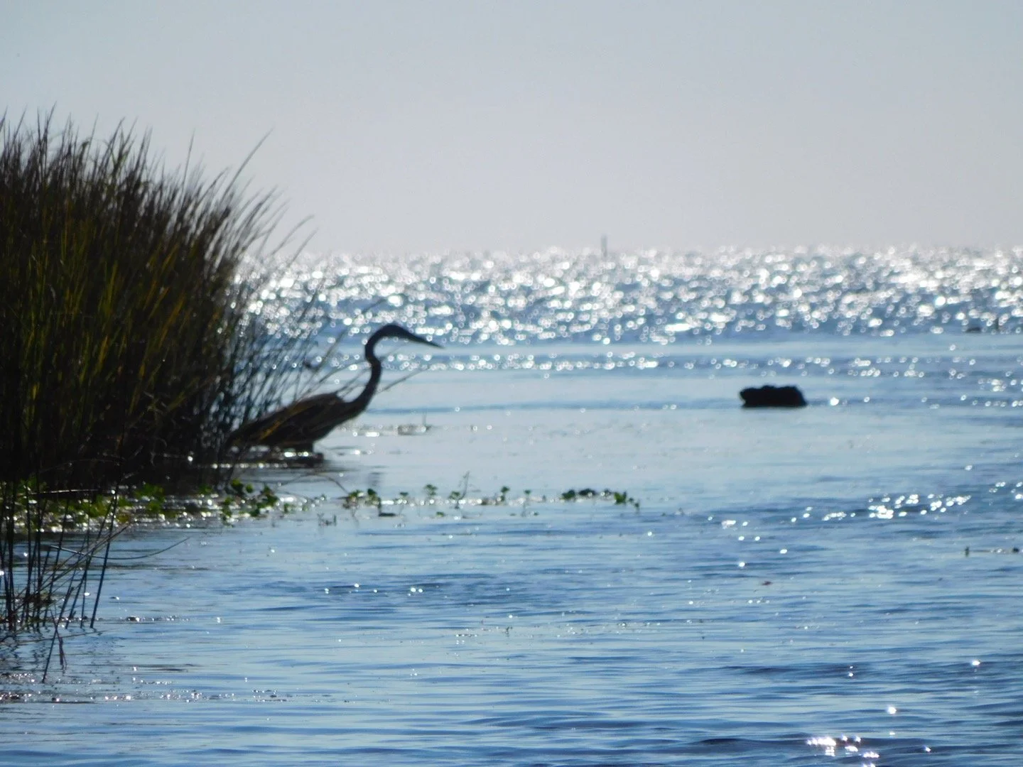
After leaving the high ground, the bayou passes the remnant of a cypress forest which once extended out from the bayou along the high piney woods. Decades ago, the cypress trees were killed by unknown causes but the most credible is that salt water from a hurricane was introduced. From about the mid point, the bayou flows through marshes that serve as a buffer between the high piney flatwoods and Lake Pontchartrain. The marshes serve as a nursery for seafood and as a recreational area for hunters, fishermen and paddlers. The last habitat is the lakefront itself with a natural ridge of high ground covered with bushes. A possible fifth habitat is submerged aquatic vegetation that harbor fish, crabs, skates and other marine life. No other bayou that flows into Lake Pontchartrain features so many distinct habitats in such a short distance.
Along the banks of the bayou at one specific site are shells of the rangia clam which indicate that native Americans once lived here. Tchefuncta culture existed from 4,000 years ago up until the arrival of the Europeans three hundred years ago. A tree line off to the west from the midpoint of the bayou also has shells that indicate another Indian camp or settlement.
The water height of Lake Pontchartrain is mostly determined by winds not tides or rainfall. If there are breezes or stronger winds from the southeast for several days, the lake will rise and then water will flow outward from the lake into the Lake Pontchartrain Basin which includes Cane Bayou and its surrounding marshes and swamps. The levels varies as much as three feet which in land that is barely above sea level can make for a huge difference in access to habitats. At the lowest level, the sandy bottomed lake is exposed at the mouth of Cane Bayou. At the highest high water, paddlers can explore for
miles into the marshes and swamps that are located between the tree line on the high ground and the lake itself.
Paddlers should know that Lake Pontchartrain is not a lake but an estuary. Since it opens to the salt water of the Gulf at two locations, the lake is tidal to a modest degree. The lake transitions from fresh in its western side to brackish on its eastern side. The area of the misnamed lake is about 630 square miles. The drainage area of the estuary is hundreds of square miles and is known collectively as the Lake Pontchartrain basin. This basin includes another smaller lake to its west, Lake Maurepas, and vast marshes and cypress and tupelo swamps plus rivers which contribute fresh water on the west end.
For paddlers, Cane Bayou has several appeals. One is that the distance is modest but has considerable variety as described above. Unless there is a strong headwind, the paddling is easy for new paddlers since Cane Bayou will have very modest or no current. Wildlife may be visible as described below. And on hot and humid days, paddlers will want to step out of their canoes at the mouth of Cane Bayou and go wading in the lake’s waters. The bottom is sandy and very firm and the slope is very gradual. The waters will feel cool and refreshing. Sometimes the water is very clear such that crabs, fish and other marine life are visible. If the humidity is low and the sky clear, downtown New Orleans is visible due south of the mouth of the bayou. The causeway is visible to the west and the sweeping arc of the lake’s shoreline extends out into the lake to the southeast.
Most paddling groups have lunch at the mouth of the bayou – either on high ground or from canoes tied off to poles in the water. If the lake is calm, then most groups paddle along the shore observing marine and bird life. If the outing is a twilight paddle, then the group will wait until twilight and then begin their slow and quiet paddle back to the launch. Time will be taken to stop and listen to the sounds of the night. If there is no moon, the leader will use a green laser to point out constellations and planets.
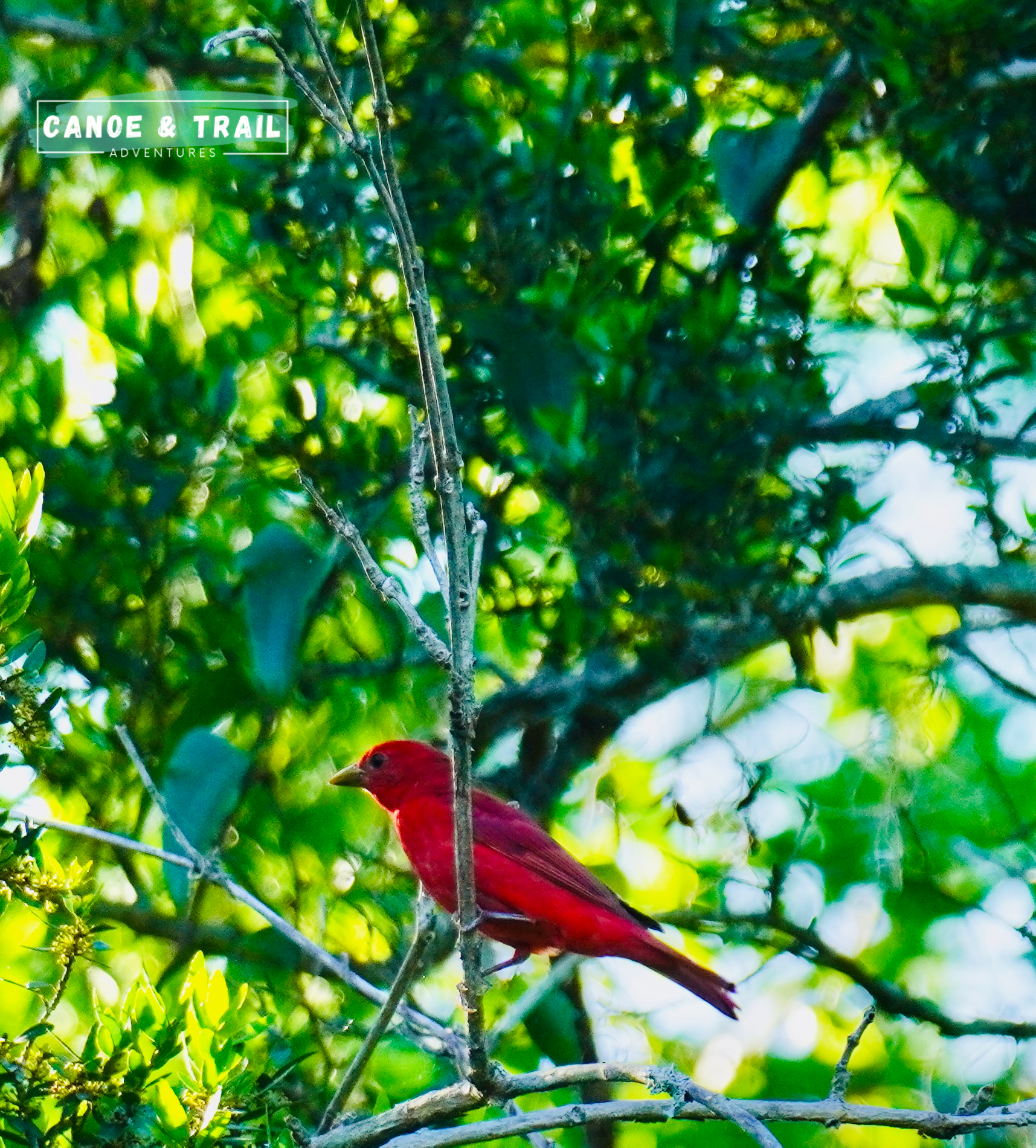
Wildlife consists largely of birds – a few reptiles. Flocks of ibises, egrets and herons can be seen commuting back and forth to feeding and roosting sites. Osprey routinely dive for dinner in the bayou or the lake. Their nests are visible from the bayou with young being raised in the springtime. Woodpeckers and assorted song birds are seasonal visitors to the living and dead trees visible from the bayou.
Reptiles are represented by alligators which are present in the bayou but do not make themselves very visible. Most paddlers never see one although at night spotlights will reveal their presence.
Cane Bayou is a representative of the habitats of the region, reflects the impacts of early and modern man and now serves as a recreational resource for lovers of the outdoors.
All pictures below were taken on Cane Bayou by our staff